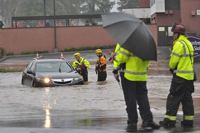
FORESTVILLE (AP) – A major storm moving through Northern California in the United States (US) dropped heavy snow and record rain, flooding some areas, after killing two people and knocking out power to hundreds of thousands in the Pacific Northwest.
Forecasters warned the risk of flash flooding and rockslides would continue, and scores of flights were canceled at San Francisco’s airport.
In Washington, more than 204,000 people – mostly in the Seattle area – remained without power as crews worked to clear streets of electrical lines, fallen branches and debris. Utility officials said the outages, which began Tuesday, could last to today.
Meanwhile on the East Coast, where rare wildfires have raged, New York and New Jersey welcomed much-needed rain that could ease the fire danger for the rest of the year.
The National Weather Service extended a flood watch into today for areas north of San Francisco as the region was inundated by this season’s strongest atmospheric river – a long plume of moisture that forms over an ocean and flows through the sky over land.
The system roared ashore on Tuesday as a “bomb cyclone”, which occurs when a cyclone intensifies rapidly. It unleashed fierce winds that toppled trees onto roads, vehicles and homes, killing at least two people in Washington.
Communities in Washington opened warming centres offering free internet and device charging. Some medical clinics closed because of power outages.
“I’ve been here since the mid-’80s. I haven’t seen anything like this,” a city of Issaquah official Trish Bloor said while surveying damaged homes. Up to 41 centimetres (cm) of rain was forecast in southwestern Oregon and California’s northern counties through yesterday.
Santa Rosa saw 16.5cm of rain in the last 24 hours, marking the wettest day on record since 1998.
The Sonoma County Airport, north of San Francisco, got more than 28cm within the last 48 hours and the unincorporated town of Venado had about 32.3cm in the same period.
In nearby Forestville, one person was hurt when a tree fell on a house. Small landslides were reported across the North Bay, including one on State Route 281 on Wednesday that caused a car crash. Rain slowed somewhat, but “persistent heavy rain will enter the picture again,” the weather service said. “We are not done!”
Flash flooding, rockslides and debris flows were possible, especially where hillsides were loosened by recent wildfires, officials warned. A hydrologist with the weather service in Sacramento Scott Rowe said so far the ground has been able to absorb the rain in areas where the Park Fire burned this summer.
“It’s not necessarily how much rain falls; it’s how fast the rain falls,” Rowe said.
Santa Rosa Division Chief Fire Marshal Paul Lowenthal said 100 vehicles were stuck for hours in the parking lot of a hotel and medical centre after being swamped by thigh-high waters from a flooded creek.
A winter storm watch was in place for the northern Sierra Nevada above 1,070 metres, with 38cm of snow possible over two days. Wind gusts could top 121 kilometres per hour in mountain areas, forecasters said.


