


CHARLESTON (AP) – Storms spawned at least one brief tornado, sent creeks over their banks and caused flash flooding on Thursday in portions of West Virginia and Kentucky, while a wintry mix coated trees and roads in ice and even dropped “thunder ice” in several states.
Residents and storm spotters in portions of Indiana, southern Michigan, Ohio and Pennsylvania reported the unusual mix of freezing rain accompanied by flashes of lightning in the unstable air.
“You ever seen that?” Brian Heffner of Spencerville, Ohio, said in a video he posted on Facebook. “I’ve never seen lightning and heard thunder during an ice storm. It’s cool.”
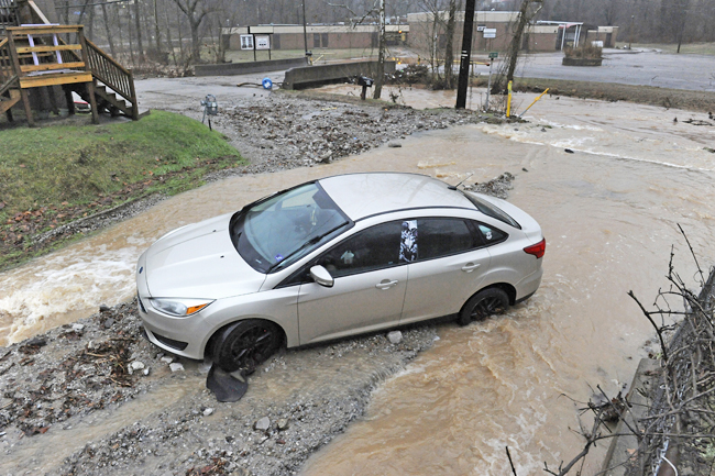
A long line of thunderstorms kept residents awake overnight with hours of heavy rains, flooding neighbourhoods, triggering mudslides and rockslides, and causing accidents where water ponded on some interstate highways. Schools in numerous counties delayed classes or closed.
Multiple drivers had to be rescued after getting stranded in the floodwaters, authorities in West Virginia said. And the rescues were not limited to humans. The Kanawha-Charleston Humane Association asked the community to adopt or foster 15 dogs after a portion of its shelter began to get flooded.
Several inches of rain in Charleston prompted county officials to activate an emergency operations centre. In Huntington, along the Ohio River, residents of some areas were told remain in their homes for several hours during flooding before the advisory was lifted on Thursday afternoon. Much of West Virginia and portions of eastern Kentucky and southeastern Ohio remained under flood warnings.
In south-central Kentucky, the National Weather Service confirmed a short-lived EF1 tornado with winds of up to 150 kilometres per hour tore apart some roofs and scattered debris in Hart County, about an hour south of Louisville. No injuries were immediately reported.
Late Thursday, severe storms with possible tornadoes moved through eastern Tennessee. The Tennessee Highway Patrol said on social media that troopers were in Morgan County ensuring resident safety and assessing and helping with structure damage.
A storm coated trees and roads in ice in several mid-Atlantic states before warmer temperatures moved in by midday on Thursday. Most areas avoided significant power outages that can accompany accumulating ice on trees and power lines.
Forecasts for several inches of snow prompted closures and delays for dozens of school systems in New England. In Maine, over 200 schools and businesses were closed or shutting early. The Kennebunk area school district was one of many that chose to close fully rather than risk a messy commute for afternoon school buses.
“Road conditions are expected to rapidly deteriorate once the snow begins, potentially putting students and staff at risk if we were to implement an early release scenario,” said district superintendent Terri Cooper.


