

The Kingdom of Bhutan, known as the ‘Land of the Thunder Dragon’, is one of the world’s most beautiful, tranquil, and mysterious places. This small, landlocked country is located between India and the Tibetan Plateau, making it one of the most remote and pristine lands on earth.
The landscape features the high Himalayan mountain ranges in the north and descends to low-lying plains in the south, with rivers forging deep valleys between high mountain passes.
Bhutan, a sovereign nation, covers a land area of 38,394 kilometre per square and has a population of around 771,608 people. Despite its mystery and remoteness, Bhutan is a top destination for many travellers.
Our seven-day trip to Bhutan began in mid-April, which is considered the best time to visit due to the pleasant, dry, and mild weather (seven degrees Celsius (°C) / 20°C).
I arrived in Bhutan armed with some interesting fun facts: there are no traffic lights, it has the highest average elevation at 3,280 metres above sea level, and it measures progress based on Gross National Happiness instead of Gross National Product.
Our journey started with a flight from Brunei Darussalam to Singapore, followed by a five-hour flight on Drukair, the Royal Bhutan Airlines, with a one-hour stopover in Guwahati, India.
Flying into Paro International Airport was a scenic and exhilarating experience, as it lies in a deep valley surrounded by mountain peaks as high as 5,500 metres. Only a small number of pilots are certified to land there, and flights are only allowed under visual meteorological conditions and restricted to daylight hours.
Upon arrival, we were greeted by the crisp, clean air and the opulently decorated Paro International Airport. Bhutan is the world’s first carbon-negative country, meaning its vast forests absorb more carbon dioxide than the country emits.
Immigration and customs at the airport were quick, and visas are issued to travellers upon entry, provided they have prior authorisation. It is recommended to book trips through reputable and licensed tour operators due to the country’s transportation infrastructure.
Our authorised Bhutan travel company arranged our travel visa, accommodations, and tour packages, which included meals, hotel accommodation, entrance fees to attractions, and a tour guide and driver.
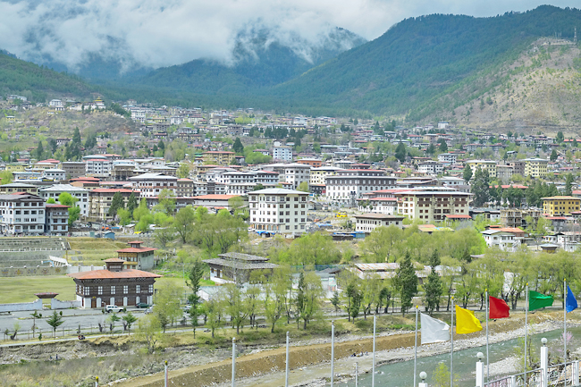
Our adventure began with a drive to Thimphu, the capital of Bhutan, about an hour from the airport. The drive allowed us to acclimatise to the altitude and take in the stunning architectural buildings, such as dzongs and goembas.
Dzongs, built as fortresses in the 17th Century, are made of stone or pounded mud and timber with wooden shingled roofs. Most are still used today as administrative offices for Bhutan’s 20 districts.
Our first stop in Thimphu was a hilltop overlooking the Trashi Chhoe Dzong, the ‘Fortress of the Glorious Religion’.
Initially built in 1641 and rebuilt in the 1960s, the dzong houses some government ministries, the King of Bhutan’s secretariat, and the central religious body. The view was magnificent, with the dzong illuminated by yellow and red lights against the starry night.
Our second day began with the Wangditse day hike, a moderate two-hour hike from the Radio Tower to Choekhortse Goemba via Wangditse. Goembas are monasteries with autonomous communities, including a temple and dormitory.
The hike offered great views of Thimphu, ending at Choekhortse Goemba (3,010 metres), one of the oldest temples in Thimphu, built in 1715. The trail was adorned with fluttering prayer flags, a common motif throughout the country.
Our next stop was the Royal Takin Preserve in Thimphu, home to Bhutan’s national animal, the Takin. Takins are rare and endangered, inhabiting forested mountain areas of 4,000 metres and above. They have a stocky body on short legs, with two-toed hoofed feet, a long nose, and stout horns.
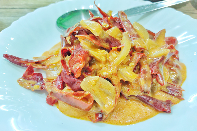
Lunch in Thimphu introduced us to Bhutanese cuisine, including the national dish, ema datshi, a chili and cheese stew made with green or red chilies, garlic, onions and local cheese.
After lunch, we visited Buddha Point at Kuenselphodrang Nature Park, featuring a 51.5-metre bronze gilded statue of Buddha Dordenma, one of the largest Buddha statues in the world.
We then visited a local archery range, where locals dressed in national costumes practiced archery, Bhutan’s national sport since 1971.
Thimphu’s city centre was bustling with commuters and tourists, and we were surprised to see that there were no traffic lights; traffic was directed by police at intersections. The Thimphu Clock Tower Square, in the heart of the capital, features rich Bhutanese carvings and paintings. Punakha was the place we travelled to when the sun rose on Day 3. The ancient capital of Bhutan is a 2½-hour drive from Thimphu across the Dochula pass.
At 3,100 metres, the pass offers mesmerising views of the Himalayas. We witnessed the Rhododendron festival at the Royal Botanical Park in Lamperi, celebrating the bloom of different rhododendron species. The festival highlighted the park’s cultural richness and its interrelation with nature.
Punakha Dzong, located at the junction of the Pho Chu and Mo Chu rivers, was built in 1637 and is the second oldest fort in Bhutan. It served as the religious and administrative seat of the region and is now the winter home of the head abbot of Bhutan and 1,000 monks.
The dzong, surrounded by blossoming Jacaranda trees, features beautiful crafted and intricate woodwork and striking murals depicting Bhutanese and Buddhist history.
Stay tuned for the continuation of our journey through Bhutan in the second part of this article. – Professor Dr Kenneth Kok Yuh Yen

