

Kasha Patel
THE WASHINGTON POST – Imagine Earth’s surface is like a stack of pancakes. The pancakes, or layers of soil and rocks, may appear fairly evenly stacked and fluffy. Over time though, the stack can become compressed, thinner and shorter.
Scientists observe this downward motion of land, called land subsidence, across the planet. While some regions of land experience uplift, many parts of Earth’s surface are sinking – fast. Scientists are especially concerned for sinking locations near the coast, which are at a higher risk for flooding as sea levels rise in a warming world. Hurricanes and extreme rainfall events can also bring more damage to such low-lying areas.
But understanding this slumping land motion is not simple, scientists said. Even within the same city, some regions may be sinking at faster rates than other areas.
“If we look at the data, we don’t see a city as a whole, uniform society. We generally see regions of hot spots where you can see parts of cities subsiding depending on what is happening,” said NASA scientist David Bekaert, who has analysed land subsidence in the United States (US) and worldwide.
Some land subsidence, Bekaert said, is related to deep natural processes over long periods of time, such as responding to plate tectonic activity or to the retreating of the glaciers from the last Ice Age. Other sinking is linked to human activity, including extracting oil, water or minerals from underground. In cities, buildings can also add weight and push land down.
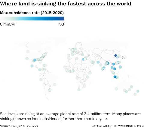
Many of the fastest sinking places in the world appear in populated areas in Southeast Asia largely because of groundwater extraction, but the US also faces substantial land subsidence.
There, you may not notice land settling around you in your daily life, but scientists found that many places are sinking faster than global sea levels are rising – increasing flood risk in coastal cities. Sea levels are rising at an average global rate of about 3.4 millimetres (mm) per year.
Regions with the highest land subsidence in the US are mainly located along the East and Gulf Coast, but here we selected a few hot spots around the country.
GULF COAST: HOUSTON
The western Gulf Coast is experiencing some of the fastest land subsidence rates in the US.
Analysing land subsidence rates in large coastal cities, Bekaert and his colleagues found Houston has the fastest peak subsidence rates – about 17mm per year from 2014 to 2020 – in the US. Other research showed parts of Houston lost over three metres (m) in elevation in certain areas since 1917.
Such land subsidence can worsen damage during extreme weather events. Researchers found that the majority of areas flooded during 2017’s Hurricane Harvey showed relatively high subsidence rates.
Land subsidence in the Houston-Galveston area is largely caused by groundwater withdrawals.
According to the US Geological Survey, removing water from fine-grained silts and clays underground compresses the aquifer and lowers the land surface.
Some regions experience high land subsidence rates because of withdrawal of local oil and natural gas reserves.
A smaller portion of land subsidence can be attributed to fault movement in the area.
GULF COAST: NEW ORLEANS
Parts of New Orleans are also experiencing high rates of sinking, due to both human-induced and natural processes. Research showed that rates are highly variable across the city, ranging from 150mm to 500mm over the past 20 years.
Past data from 2009 to 2012 showed the highest subsidence rates along the Mississippi River near industrial areas in Norco and Michoud – experiencing up to 50mm of sinking a year. To the east of Norco, the Bonnet Carré Spillway, intended to reduce flood risk for New Orleans, experienced up to 40.6mm of sinking a year behind the structure.
NASA reported a primary contributor is pumping groundwater. Subsidence deeper underground is also caused by the shifting of faults, according to the city of New Orleans.
While Houston and New Orleans are notable subsiding locations, other places in the Gulf also experience high rates. In a large area north of Tampa Bay, subsidence rates have been clocked at up to 6mm per year, about twice as much as global sea level rise, from 2015 to 2020 due to groundwater pumping. The Tampa Bay area is also relatively flat, meaning rising seas may overwhelm large swaths of the low-lying area.
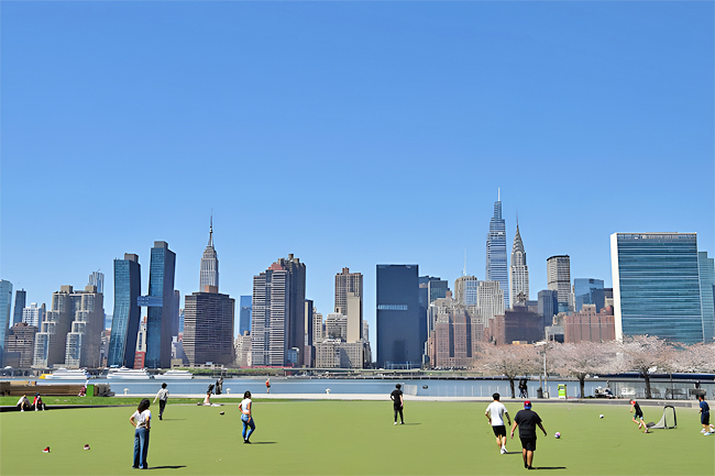
EAST COAST: NEW YORK CITY
With more than eight million people, New York City is the most populated city in the United States. It’s also sinking about 1mm to 2mm per year, on average.
People living in subsiding cities like this may see higher sea-level rise – rates up to four times faster – than more stable regions.
“If now the water is going up and your land is going down, then your houses will be flooded,” said Matt Wei, a geophysicist at the University of Rhode Island. “That’s the issue.”
Wei said much of the city’s land subsidence are responses to glacial retreat after the most recent Ice Age. During the last Ice Age, ice sheets weighed heavily on the land and caused the crust beneath places such as Canada and the northeastern US to stretch and sag.
Places on the periphery of those sagging areas, though, such as around New York and the Chesapeake Bay, bulged upward.
When the ice sheets began retreating about 12,000 years ago, those sagging areas started to rise back up while the bulging areas are settling back down.
Wei said to think of it like a balloon. If you push down on a balloon, parts near your hand will go down while other parts farther away will go up. Once you remove your hand, the balloon will try to bounce back to its original shape, causing some sections to rise and others to lower. He said the same process plays out on Earth except on “a much larger scale and also a much slower speed”.
For the most part, Wei said land subsidence in New York City is consistent with what researchers anticipated from this glacial rebound. However, some sections of the city showed higher rates of subsidence than expected. In a new study, Wei and his colleagues found that the weight of buildings around New York City are actually pushing down the land in some areas, contributing further to land subsidence. While the average rate in the city is 1mm to 2mm per year, some areas are experiencing about 4.5mm per year.
“New York City is sinking not because of the weight of the buildings. It’s mainly because of the glacier rebound,” Wei said. “But there are places suggesting the weight of the buildings might have contributed to the accelerated rate.”
MID-ATLANTIC: NORFOLK
Norfolk has the highest rate of sea level rise on the East Coast. Land subsidence plays no small part. Virginia’s Hampton Roads area is sinking at around twice as fast as waters are rising. In a study from 2020, Bekaert and his colleagues found Norfolk and Virginia Beach were sinking at more than 3.5mm per year, with some sections sinking slower or faster.
Much like New York City, parts of the Mid-Atlantic are also affected by glacial rebound. Norfolk is also experiencing subsidence from a meteorite that created a hole millions of years ago. Softer dirt entered the crater and has since compacted and shifted downward, causing sinking to land around the crater.
Groundwater withdrawals are also exacerbating rates on local levels. Bekaert said historically, paper mills in Norfolk did a lot of pumping, but operations ceased with new regulations. The city is experimenting with a new project that would restore water in the aquifer and reverse long-term pumping.
Norfolk may stand out on the East Coast, but many areas along the coast are also combating high rates of subsidence and sea level rise. The Chesapeake Bay has been experiencing around 4.6mm per year of sea level rise, exacerbated by land subsidence.
WEST COAST: CALIFORNIA’S CENTRAL VALLEY
Sinking along the West Coast is comparatively small to the East Coast, but that doesn’t mean land subsidence isn’t a problem.
In the Pacific Northwest, Bekaert said a main driver on a broader scale is tectonic plate activity, where one plate is subducting, or going underneath another plate. Depending on where you are, he said, you may experience uplift or gradual subsidence. As you move further down the coast, the plates start to move next to one another, which doesn’t provide much vertical motion. Instead, human-induced processes take over.
Overall, data along the western coast show rates are mostly below 3mm per year, except near areas like San Diego, which has experienced large amounts of human-induced sinking.
Further inland in California’s Central Valley, excessive pumping of groundwater for agriculture has caused the land to sink significantly. Since the 1920s, sections of the San Joaquin Valley have sank by as much as 8.5m. Groundwater pumping becomes even more problematic during droughts, exacerbating subsidence problems. Data from 2015 showed some spots subsided at rates as high as 600mm per year.
“There can be hot spots within cities, where you see different subsidence rates,” Bekaert said. “Often, they are related to the local human-induced fingerprint that is taking place.”


