ANN/THE STAR – Penang Island’s hilly woodlands make up about half of its landscape – an aerial view reveals a terrain rich in greenery.
Within these protected forests, numerous trails await hikers.
According to AllTrails, there are 54 trails, while the Penang state government provides GPS maps for 26 popular paths.
Many trails lead to Penang Hill’s peak, offering breathtaking panoramas, while some branch off to unique scenic spots.
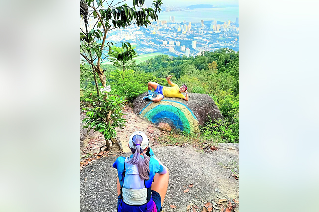
One trail, favoured by locals and visitors alike, leads to two remarkable formations: Astro Rock and Rainbow Rock.
This beginner-friendly trail spans less than 10 kilometres (km) with an elevation gain of around 550 metres (m), taking about two to three hours to complete. Hikers are advised to bring at least 1.5 litres of water.
The trail begins at Penang’s City Park (formerly Youth Park) via the Sun Gate entrance across from the auditorium. Follow the cement path, pass a stream, and ascend steep rocky sections with ropes.
About 1.5 km in, where the path diverges, look for a long stick in the ground with a white helmet on top.
This marks the way to Astro Rock – head left, descending 200m to a large, rounded boulder facing east, offering panoramic views of George Town, Bukit Mertajam, and Penang Bridge.
Thanks to its eastern position, Astro Rock provides shade from the afternoon sun around 4.30pm, making it ideal for a scenic break.
There’s a covered hut with benches, and the spot is perfect for a coffee break, with some hikers even bringing portable stoves for a quick meal.
Penang Turf Club lies directly below, so on race days, a pair of binoculars might enhance the experience.
To reach Rainbow Rock, return to the white helmet marker and follow the trail uphill.
This path leads to Station 39, a rest area with basic amenities. Friendly dogs may join hikers on this route, often acting like guides.
From Station 39, head to the washroom and take the upward path towards the “highway”, a common route linking Moongate to Station 84.
Cross this “highway” to find the path to Rainbow Rock.
Less than one km further, watch for a narrow trail on the left leading to Rainbow Rock, where a painted rainbow and sweeping island views await.
After taking photos at Rainbow Rock, hikers can either retrace their steps or follow the highway downhill towards Moongate at the base. For those with energy left, the opposite direction leads to Bukit Cendana, offering views from an elevation of 550m. This path passes the ruins of British-era Convalescent Bungalows, built as retreats in the 19th Century. Continuing down from Bukit Cendana leads to the Penang Hill Jeep Track and eventually to the Penang Botanic Gardens.

