


Scott Wilson
THE WASHINGTON POST – Among the coveted places to live in this city, if you have the money, is West Cliff Drive in the California, United States. How much longer that will be true is the question.
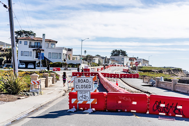
The cliff-top road is falling into the Pacific in large chunks, leaving gaping holes and closing lanes along a normally busy street. A process that has taken place over centuries is quickening after a rare series of winter and spring storms that brought abnormally high tides, potent surf and lots of rain.
The sea is taking back the land. It is happening at various speeds along much of California’s coast, changing the ragged western edge of the country and threatening neighbourhoods, highways and ways of life.
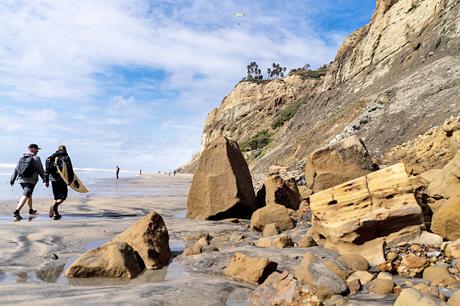
For decades, California has built to the brink of the continent, a risk-reward calculus where the reward of a sparkling Pacific Ocean with your morning coffee easily trumps some future risk of a collapsing cliff. The cliffs, some more than 300 feet straight up, star in car commercials and TV shows, the edge-of-seat finales of action movies and, in real life, serve as the perfect take-off point for paragliders.
But today it is some of the state’s most famed cliffs, overlooking about 500 miles of California’s coast, that are among those most imperilled by rising sea levels and more potent storms. In Isla Vista, the site of the University of California at Santa Barbara, apartment buildings regularly lose front patios and facades to the encroaching ocean, sliding down 200-foot cliffs toward the beach.
A major coastal railroad track between Orange County and San Diego is closed frequently – most recently in April after new slides – as erosion undermines the ground beneath it.
Repair costs for several sliding sections have reached USD14 million so far. Highway one, the age-old tourism route along the central coast of the state, is closed frequently because of landslides. The Lost Coast in Humboldt County to the north, is losing its cliffs at greater rate than any place in the state.
“I never intend to move,” said a 67-year-old retired sculptor Brian Curtis, who lives a few blocks from the recent road collapse in Santa Cruz, while walking his dog, Ziggy on a windless morning along West Cliff Drive. “At this point it’s gather enough information and determine how much is going to fall away before making any decisions.”
The dreaded term “managed retreat”, a euphemism meaning that roads, houses and sometimes whole neighbourhoods are removed or moved back from the shifting coastline, has been broached in community meetings here as a real possibility. The cost is exorbitant.
In Santa Cruz alone, the price would run into the tens of millions of dollars, just to build back neighbourhoods as they were. It would skyrocket once the actual moving of homes is factored in.
“How are we going to cover what we need to do right now?” said the city’s Sustainability and Climate Action Manager Tiffany Wise-West. “Then what do we want it to look like in the future?”
While many coastal towns on the East Coast are considering plans to move houses back from the rising waterline, California’s unique cliffs offer a different kind of problem – the sheer vertical rise and the soft soils prone to unpredictable slides toward the sea.
That topography has collided with the state’s new climate of extremes, characterised by mega-fires, years-long droughts, dry valley wells and the fallow fields of the San Joaquin.
This winter delivered a novelty – rain, snow and pounding swells that in some cases set records, according to state officials.
A year ago, the National Oceanic and Atmospheric Administration predicted that sea level would rise eight inches in California and along the West Coast within the next 25 years. At the same time, though, the state government is trimming funds for and discouraging cities from strengthening weak bluffs and cliffs with relatively short-term measures. In his budget this year, Governor Gavin Newsom proposed a cut of more than USD700 million, or roughly 43 per cent, from the “coastal resiliency” fund that is used to bolster the shoreline. California is facing a USD31.5-billion deficit after several years of surplus. The California Coastal Commission, which weighs in on nearly every project planned along the coast, has been advising cities against past finger-in-the-dike practices to protect coastlines. The method is called armouring – the piling of boulders, construction of retaining walls and installation of bluff-side netting, which has been used in the aftermath of storms and erosion.
The measures are no longer effective, according to several studies, merely serving to guide rising seas toward other weak spots along the cliffs. The Coastal Commission is rejecting an increasing number of armouring proposals, and instead pressing places such as Santa Cruz to begin discussing the managed retreat of roads and even some homes. The commission’s position has left Santa Cruz with only very expensive alternatives as the erosion worsens.
In a report prepared before the recent storms assessing Santa Cruz’s coastal protection plan, the commission concluded that it “does not adequately protect coastal resources”, a key component of Santa Cruz’s tourism-heavy economy. The commission favours managed retreat, the only measure it sees as a long-term solution.
The expectation among experts is that erosion will accelerate even more as climate trends continue – amid a prediction of historically damaging weather this fall.
Weather and climate forecasters said there is a better-than-even chance that the phenomenon known as El Niño could occur starting this summer and last through the winter, steering storms into the region, and causing more landslides and erosion. Usually, trade winds blow west off the coast of South America, pushing out warm surface water and replacing it with cold deep water that extends up the Pacific coast.
El Niño weakens the winds, and can even reverse them, bringing warm water and more intense storms, bigger surf, higher sea levels and heavy rain to the coast.
Although forecasters said it is still early to be sure El Niño will return, the National Weather Service puts the chances it will at 63 per cent.
The risks are real, as has been proven. A study published in March 2021 by Geomorphology found that the El Niño of 2015-16 caused significant erosion along nearly 90 per cent of Northern California beaches and 79 per cent of those in Southern California.
“It depends on what kind of El Niño it is,” said a researcher specialising in coastal geomorphology at the Scripps Institution of Oceanography at the University of California at San Diego Adam Young. “But typically El Niño drives more surf intensity and more impact.”
About 450 miles south of Santa Cruz, Young is monitoring another series of beachfront cliffs as they crumble onto the sand.
At Black’s Beach, north of San Diego, soaring cliffs reach up hundreds of feet and, at their edges, multimillion-dollar homes perch perilously on the soft ground.
“Cliff erosion has been going on for thousands of years,” Young said. “But, of course, the difference now is how close to the cliff edges we build.”
The recent storms have left their mark, including one of the largest single landslides Young has seen in more than 15 years working at Scripps.
The slide is more than a football-field wide and began high up the cliff, carrying shale, boulders, oyster shells and other debris with it.
Young pointed out at least a half-dozen other cliffs in imminent danger. “The process of failure is already beginning there,” he said, referring to one showing schisms in its face.
Young has developed a three-dimensional radar system to map even the smallest shifts in these cliffs. “This winter has been very active with slides,” Young said.
“But every time we do this I learn something new about the cliffs and what is happening to them.” Nearly every week, along hundreds of miles of California coast, the consequences of erosion can be seen or felt. No place is it on such vivid display as in Santa Cruz, a town with a hippie ethic, an amusement park as its centrepiece and surfing as a religion.
More than 5,000 tonnes of road, rock and bluff sheared off into the Pacific in Santa Cruz during the recent storms, thrashed by a combination of rising ocean levels, extreme tidal swings and rough seas.
Yet there is an attitude of happy oblivion along West Cliff Road, an “it can’t happen here” feeling that brought out the bikers and runners and baby strollers on a recent sunny day.
The one lane still open is now only used by pedestrians, a boon for some amid the bad news.
“The road can be adapted to what’s necessary, and the rock walls and other stuff they put in will help hold it off for some time,” Curtis, the retired sculptor, said. “That’s my plan at least.”
Steamer Lane is among California’s most famous surf spots, a long point break leading from a rocky promontory that juts out into the Pacific and runs all the way into the beachfront gateway to downtown Santa Cruz.
In February, a video circulated of a large chunk of the rocky cliffs where surfers wait to take off collapsing with a huge, frightening splash.
A usually brave bunch, surfers paddled frantically away from the rock fall. Not one left the ocean.
Already another large crack has appeared in roughly the same spot where the first chunk sheared off – the signs of imminent failure and another reshaping of California’s coast.
“That storm was a blue-moon storm, ones that just don’t happen with any regularity,” said a Santa Cruz native who treks out to the edge of the point Zephyr Christensen, climbing over the fence festooned with “falling rock” warning signage.
“I don’t know what’s going to happen but no one is going to stop surfing this place,” Christensen said. “But I’d be bummed if I see the break changing because of this damage.” said.
“But these were trade-offs we thought we’d be making 30 years from now. Not today.”

